Deepwater Point and 2 Bridges Loop - Djarlgarro
- Out and About

- Jan 23, 2020
- 4 min read
Updated: Oct 18, 2025

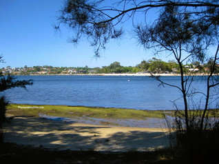
Stunning river views are not the only thing on offer around Deepwater Point which sits on the Canning River, Djarlgarro, midway between Canning Bridge and Mt Henry Bridge. There are several walks you can do depending on the time you have available or you can choose any one of these areas and just spend some time enjoying the river or the playground. Apart from the stunning views we found Canning Bridge with it's surprise artwork underneath and Mt Henry Bridge with dedicated walkways on both sides underneath the road bridge (a good 10 minute walk across each way!) to be highlights. An additional option from Canning Bridge to Heathcote is explored in a separate blog.
The walks are flat and perfect for prams or kids on scooters and although the paths are dual use the fast cyclists often use The Esplanade so any bikes you encounter approach at a more leisurely pace. Dogs are permitted on lead on the pathways.
You can start your walk from Deepwater Point, where there is paid parking, unless you get lucky and find a spot on the street. It gets really busy here. There is a DOME cafe, a playground, a small river beach, a jetty, barbecues and picnic facilities here.


You could also park at Mt Henry Bridge Reserve where there is free parking, a jetty, toilets, drink refill station and if you are lucky a coffee van. In March 2024 Mount Henry Bridge Reserve underwent an exciting transformation, becoming the City of Melville’s first ever intergenerational activity.


Deepwater Point to Canning Bridge
This is the most popular section of this walk and closely follows the river so you have great views of the city heading towards Canning Bridge and great river views on the return. Along the way you will come across several sit spots complete with beautiful mosaics depicting life on the river. Smaller mosaics dot the pathways making this walk really interesting for the kids to explore.


Enjoy the city views along the way as you pass Rookwood Street Jetty. As you approach the Rowing Precinct wander around the various rowing clubs to find the murals - these feature on the Canning Bridge Mural Art Trail. The walk is about 1.8km each way and will take about an hour there and back.


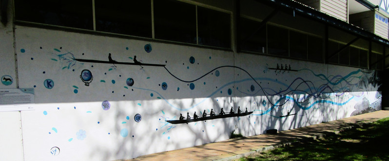


When you get to Canning Bridge walk under the bridge and look along the wooden piers and struts. The underside maintenance walkway has been decorated and painted and is really colourful. Take the time to walk across the bridge and have a look from both sides.


Mt Henry Bridge to Deepwater Point
You can do this in either direction - we started at Mt Henry Bridge Reserve as parking is a little easier to find here. The path follows the river along The Esplanade (which is great as the fast bikes stick to the road making for a more relaxing walk). Again there are mosaic tiles in the pathway and at the sitting spots depicting life on the river. You can explore both the Mt Henry and Gunbower Jetties. After 20 minutes (1.6km) you will arrive at Deepwater Point ready for a coffee and a play before the return leg.


Either way when you are at My Henry Bridge make sure you head up the pathway and walk the pedestrian access paths under the bridge. It will take about 20 minutes to walk across on one side and back on the other!
The full walk from Mt Henry Bridge to Canning Bridge is 3.2km (40 Minutes) each way.

Mt Henry Bridge to Bateman Park
You can also explore further heading south from Mt Henry Bridge along a shared use path to Thomas Middleton Park. This is the end of the path but you can easily continue along Orana Road, where the houses have river frontage, Spinaway Crescent and Moonlight Cove. Keep an eye out for historic Grasmere - Bateman Homestead - as the path resumes and takes you through Bateman Park where you will find the boardwalk at Kaalitj-ngort Koondaam, Dragonfly Dreaming - part of the Brentwood Living Stream project. If you continue across the bridge you pass through Bull Creek Wetland Catchment and on to Yagan Park almost closing the loop with our Riverton to Shelley Beach Loop. The section past the bridge runs alongside busy Leach Highway.
The walk from Mt Henry Bridge to the Bateman Park boardwalk is 1.4km (20 minutes) each way.


Two Bridges Loop
This is the walk we actually did. We started at My Henry Bridge and walked past Deepwater Point to Canning Bridge. We crossed over Canning Bridge and explored underneath where we discovered the artwork and colourful slogans.


We then took the dual use pathway on the eastern riverbank back to Mt Henry Bridge where we really enjoyed the experience of crossing this longer than expected bridge. The actual walk along the eastern side was marred by traffic noise from the freeway so I probably wouldn't do this again on foot - maybe by bike.


The loop walk is around 7km and will take upwards of 90 minutes. We took just under 2 hours but spent a bit of time looking around.

To read more blogs go to:
I love wandering along trails, both marked and unmarked, and sharing my discoveries with my Out and About FNC community. If you enjoy reading my blogs please consider a small donation which will be used towards the costs of keeping the website up to date and relevant.
In the spirit of reconciliation Out and About- Family Nature Connection acknowledges the traditional owners of the Wadjak boodjar (Perth land) and their connections to land, sea and community. We pay our respect to their elders past and present and emerging and extend that respect to all Aboriginal and Torres Strait Islander peoples today.


Comments