Lesmurdie Falls
- Out and About

- Oct 16, 2019
- 4 min read
Updated: 3 days ago

Lesmurdie Falls is a Perth favourite and it easy to see why. With walking trails ranging from easy to more challenging combined with a magnificent waterfall and stunning views across the Perth Coastal Plain this is a great place to spend a day out and about.
LESMURDIE FALLS PICNIC AREA
This area has picnic benches and toilet facilities and is at the main car park off Falls Road. There is also a large information board and map detailing the different walking tracks and also giving the geological history of the area.
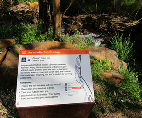
LESMURDIE BROOK LOOP TRAIL
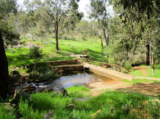
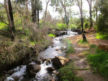
The Lesmurdie Brook Loop Trail is a 1.5km loop developed by the Friends of Upper Lesmurdie Falls and the Lesmurdie and Districts Community Association. The trail meanders along the upper Lesmurdie Brook area. Paths are universal access so are pram friendly. There are lots of places for kids to interact with the brook, crossing handcrafted bridges or playing on the rocks. There are three parking areas along Falls Road with direct access to this trail including the main picnic area car park. The best time of year is winter when the water flows along the brook or Spring when the wildflowers are out.


FALLS TRAIL
The Falls Trail is a 640 m return trail that extends to the two lookouts over the head of the falls. Although it is paved it wasn't really universally accessible as the prams were having a bit of a battle and there are stairs at the lookouts.


FOOT OF THE FALLS TRAIL
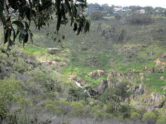
This 2 km return trail is an extension of the Falls Trail and involves a steep descent followed by a short flat but rough detour to the foot of the falls and then returning uphill via the same path. The trail is narrow and quite rough and muddy in places after rains. There are a number of steps to negotiate. It was quite busy on the day we were there and the path is only just wide enough to comfortably pass someone going the opposite direction. The falls provide a magnificent backdrop and along with the profusion of Spring wildflowers it is a very pretty walk. Towards the bottom things got a bit tricky as there are a number of tracks, most of them muddy, but we kept heading downhill and eventually came out near the car park on Palm Terrace from which there is easy access to the Foot of the Falls for those not able to walk down the scarp.


We followed the narrow track to the Foot of the Falls and were rewarded with a spectacular view of the falls cascading down. There were a lot of people here so we didn't get right up to the base but I could feel the power of the falls from where we were. The rocks are slippery at this time of year so be aware of your kids if they are the adventurous type. During the dryer months you would be able to clamber over the rocks and get up closer.


On the return there is a sign to Lions Lookout and we followed this trail which was very rough. We found some informal trails which led back to the main trail - intersecting it about half way up but these trails are not marked and are very rough. After emerging back on to the main trail we returned up the scarp this time with views of the upper falls in front of us. The other side of the brook had a yellowish tinge from the wildflowers.


VALLEY LOOP TRAIL
This 3km loop trail can be started from the Lower Lesmurdie Picnic Grounds and car park off Palm Terrace or from the Picnic Area at the top of the falls off Falls Road. In Winter and Spring when the brook is flowing you actually need to ford the water (i.e. get wet feet) to complete this trail or you can divert via the Palm Terrace carpark to get around the brook. After crossing the brook at the base of the falls the trail climbs steeply up the scarp. The trail is rough, rocky and uneven as it climbs towards The Shoulder, a lookout over the lower face of the falls. At the top of the escarpment the trail continues o to meet up with the Lesmurdie Brook Trail at the lower bridge. Although rocky this is a more gentle section. There are numerous side trails including a very steep one which is an optional shortcut to the Brook if you are feeling adventurous. After meeting up with the Lesmurdie Brook Trail the Valley Loop continues on to the Head of the Falls Lookout platform before descending the scarp on the Foot of the Falls Trail.


SHOULDER TRAIL
This is a 1.5 km there and back trail. Start by crossing the brook just down from the Lesmurdie Falls Car Park. The trail ascends via a rough paved pathway to a rocky outcrop with stunning views across the coastal plain before joining the Valley Loop Trail to The Shoulder. There is a bench here so you can sit and enjoy the view over the falls before retracing your steps. As you descend to The Shoulder the trail is narrow, rocky and quite rough in places. At the top look for the paved pathway as there are several trails and although main trails are signposted it can be a bit confusing.


Lesmurdie Falls is a lovely place to explore with trails offering varying degrees of difficulty. As this is a very popular area there are many informal trails so be aware of personal safety.


You may wish to try other trails and points of interest in Kalamunda:
To read more blogs go to:
In the spirit of reconciliation Out and About- Family Nature Connection acknowledges the traditional owners of the Wadjak boodjar (Perth land) and their connections to land, sea and community. We pay our respect to their elders past and present and emerging and extend that respect to all Aboriginal and Torres Strait Islander peoples today.
As always when hiking in the bush please help to reduce the spread of Phytophthora Dieback by sticking to the tracks and paths, staying out of quarantined areas and, if possible, clean your shoes before and after hiking. A spray of 70% methylated spirit and 30% water can be effective.


Comments