Wardun Beelier Bidi - a Whadjuk Trail
- Out and About

- Apr 3, 2024
- 7 min read
Updated: Aug 25, 2025

The Wardun Beelier Bidi (Trail) lies on Whadjuk Noongar land and connects the Indian Ocean with the Swan River. It is an aboriginal cultural walk with directional markings that meanders through Cottesloe, Claremont, Peppermint Grove and Mosman Park. The 17.4km trail is cycle friendly and suitable for all walkers, with a moderate level of fitness required. The trail mostly follows sealed pathways with a short section of beach sand (with the option to walk further along the beach) and a short unsealed section within Peppermint Grove (with the option to remain on sealed pathways).
This is a very long trail so we hiked it in several sections - Grant Marine Park to Keanes Point (90 minutes), Keanes Point to Minim Cove (60 minutes) and Minim Cove to Grant Marine Park (1 Hour 45 minutes). Officially the trail starts and ends at Grant Marine Park in Cottesloe.
From Grant Marine Park head south along Marine Parade skirting the back of the carpark alongside John Black Dune Park and then crossing Napier Street to explore the lovely Cottesloe Civic Centre Gardens.


Emerging on to Broome Street head south to Forrest Street and follow this leafy street to the Metal Balloon sculpture on Curtin Avenue. Here you will cross the railway tracks near Cottesloe Station so this is a great access point to the trail if travelling by public transport.


Head south along Railway Street to the Napoleon Street shopping strip and cross Stirling Highway before walking along Leake Street, joining a section of the Peppermint Grove Heritage Trail.


At The Esplanade follow the paved path upriver turning into Foreshore Reserve just after McNeil Street at The Devil's Elbow then follow the unpaved riverside path back along the river passing Scotch College Boatsheds, Freshwater Bay Jetty and the giant Moreton Bay Figs with massive branches overhanging the water providing a perfect playground.


Keanes Point is a great stopover point as there is a cafe, a playground, toilets and parking.


From here the trail follows the Mosman Park Heritage Trail along the Mosman Bay Foreshore which has stunning views out across the Swan River. Passing the famous Mosman's restaurant the path starts to climb quite steeply alongside Jabe Dodd Park before curving back along the cliff tops at Bay View Park.


You will pass the Dragonfly statue as you enter Bay View Park before coming to the Bay View Lookout. If you are unable to manage the steep uphill section there are several parking bays here and also a memorial wall but the stand out is the VIEW! Spectacular views across Mosman Bay to the city skyline and then swooping around to Point Walter.


The trail continues along Owston Street with it's beautiful homes and glimpses of the sea way in the distance to the west, a reminder of where this trail is heading!
When walking this section and following the Mosman Park Heritage Trail (East) we detoured to explore The Coombe Reserve, which is a hidden treasure. Otherwise continue along Owston Street and turn left onto Wellington Street which skirts the Mosman Park Golf Course. Turn right at the end of Wellington Street into Bateman Street. There is another detour here along Caporn Street and Chidley Way to Chidley Point Reserve. If you drive here there are lots of parking bays on the upper level and you can also drive down to the point where there are limited bays. Stairs will take you from the upper carpark to the beach on Chidley Point where the Swan River enters Blackwall Reach.


From the upper car park wander down Chidley Way to the left to discover Green Place Reserve, another tiny reserve tucked below riverfront homes. There are a few parking bays here and a short path leading to a grassy area and jetty.


If you have walked down to Chidley Point you can shortcut by turning left onto Caporn Street and then right onto Bird Street or Riverside Drive which will take you through to Marshall Street to rejoin the main trail which turns left onto Marshall Street at the end of Bateman Street.
Marshall Street curves around following the edge of Blackwall Reach. On the other side of the river is the Jenna Bidi Yorga trail which follows the southern side of Blackwall Reach. Just past the parking bays along Marshall Street the path diverts into the bush - first on a paved path which then becomes a boardwalk bringing you down from the cliff top to the river foreshore at Point Roe Park.


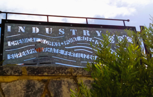
This is where the Cottesloe Refinery operated from 1930 -1997 when it was demolished. The 5 storey red refinery supplied WA's sugar needs and dominated Point Roe. Now there is little trace of the area's industrial past and the river is pristine with grassy parklands and a small river beach reserve for wading birds complete with bird hide.


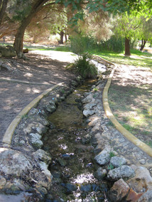
This is also where you will find the amazing natural playground Russell Brown Adventure Playground which was our destination on our first time walking this trail. The kids loved the playground which has loads of hidden activities. It was almost kid free while we were there so they had the run of the giant swinging rope, the cubby, the climbing trees, ropes and swings. Of course the running water in the stream was the most popular activity. Parking can be found at the nearby Tennis Courts but will be limited on days when they hold lessons or tournaments. If you don't mind a short walk (not as far as we ventured) there is parking at Tom Perrott Reserve and there were a few bays along Marshall Street.


The walk from Keane's Point to Russell Brown had taken about an hour with small kids and excluding detours at The Coombe and Chidley Point which we explored on another occasion.
This is where we split the 10.5km Mosman Park Heritage Trail into two sections: Keanes Point to Minim Cove and Minim Cove to Keanes Point via Buckland Hill and Memorial Park
However the Wardun Beelier Bidi Trail continues west along the river. Before you leave the flats explore the path on the right which features collaborative artwork by school kids illustrating various aspects of local history including the fossils, indigenous past, native animals and plants, industry, early settlement, farming, sport and war.


At the top of the hill where paths intersect take the left hand path next to the Minim Cove interpretive sign. Follow the path down around the large power pylon and you will come across a rough staircase leading to a small jetty.


The lower path hugs the edge of the river which has steep cliffs as you head back along along Minim Cove passing the site of the Fertiliser Factory and with magnificent views down the Swan River to Rocky Bay and the Old Soap Factory. Continue on to Garungup Park with it's decorative panels depicting the History of River Industry prior to redevelopment. Garungup is the Noongar name for two caves in the bay to the west, said to be the final resting place of the Waugyl before it tunnelled underneath the limestone cliffs to Gabee-Wardun, the Indian Ocean.


Head up the hill and on to Edwards Parade. There are some smaller car parks here. At Pethybridge Heights take a detour east into Mt Lyell Park which has interesting artworks and a lookout with fantastic 360 degree views across the Swan River. If you have kids in tow you may wish to divert to the Spider Sculpture Park for a quick play.


From My Lyell Park return to Edwards Parade to resume the Wardun Beelier Bidi Trail through Swansea Park, around the tennis courts and into Buckland Hill Park where you will find Leighton Battery and the Buckland Hill Tunnels established during WW2. The gun battery was established to overlook and protect Fremantle Harbour and there are stunning 360 degree views from the raised platform. On a previous occasion we have done the tour of the tunnels on a Sunday, delving deeper into the fascinating history of this important defence post during WW2.


At Leighton Battery the Wardun Beelier Bidi splits from the Mosman Park Heritage Trail and heads south adjacent to Stirling Highway crossing first McCabe Street and then crossing to the western side of Stirling Highway. Opposite the old Matilda Bay Brewing Company take the bridge across the railway lines to Curtin Avenue and Leighton Beach.


You can follow the footpath or walk along the beach heading north to Mosman Beach. At the northern end of the carpark leave the beach and wander through the parkland to see the Old Cable Station and the Vlamingh Memorial before passing through the Cottesloe Nature Discovery Space and then either along the footpath or the beach into Cottesloe. We walked this section as part of our Cottesloe Coastal Walk.


You will pass Dutch Inn Beach and South Cottesloe Beach and detour to the Arch Monument and Cottesloe Sundial on Murdurup Rocks, positioned overlooking the Cottesloe Groyne. Keep heading north along the coastline to Grant Marine Park to complete the loop.


The trail is well marked with directional signs as below including the icon of the Weedy Sea Dragon, which live along the Cottesloe coastline. Look for triangular trail markers as depicted in footpaths and bollards along the route.


A Google Map option is available for phones, or can be printed from the webpage: https://www.whadjukwalkingtrails.org.au/trails/wardun-beelier-bidi/.
A free APP is available for download at everytrail.com for smart phones providing a clearly-mapped off-line route www.whadjukwalkingtrails.org.au
Great audio guides are available with QR codes on your smart phone.
To read more blogs go to:
I love wandering along trails, both marked and unmarked, and sharing my discoveries with my Out and About FNC community. If you enjoy reading my blogs please consider a small donation which will be used towards the costs of keeping the website up to date and relevant.

In the spirit of reconciliation Out and About- Family Nature Connection acknowledges the traditional owners of the Wadjak boodjar (Perth land) and their connections to land, sea and community. We pay our respect to their elders past and present and extend that respect to all Aboriginal and Torres Strait Islander peoples today.


Comments