Jarrahdale and Serpentine - A Day in the Country
- Out and About

- Jun 30, 2022
- 8 min read
Updated: 7 days ago

Jarrahdale, one of our oldest settlements, is a small historic town nestled in the Darling Range 45 kms south of Perth. Surrounded by national parks and bush reserves Jarrahdale was once prime jarrah milling country and much of the town heritage reflects this. Jarrahdale's forests, parks, rivers, orchards and vineyards offer a great escape in nature away from modern city life. It's National Trust listed heritage gives you glimpses of a bygone country life.
Driving in along Jarrahdale Road from South West Highway you pass through green (in winter) pastures before climbing a windy, scenic road into the town. Just before you enter the main town you will find the Whitnish Cottage and Machinery Museum on your right and then the Centenary Log, which honours 100 years of logging, on your left.

As you cross the bridge across Gooralong Brook you will find St Paul's Anglican Church on your left and next to the church is The Old Post Office Museum, built in 1896, which serves as a tourist centre as well as a museum run by the Jarrahdale Heritage Society. Unfortunately we were there well before the 10am opening time so we didn't get to have a look. There is limited parking and toilets available next to the Old Post Office Museum and this is where we started our walks to explore Jarrahdale township. Make sure you cross the road from the Old Post Office and climb the driveway off Oak Way to Necessiteas for Life - a quaint shop selling all manner of loose leaf tea and tea paraphernalia.


The Old Post Office is also the start point of many guided walks run by the Jarrahdale Heritage Society. These walks are led by trained and experienced volunteers and may have a guest guide who will provide insight to the wildflowers, fungi, birds, etc. Walks are conducted between March and November. For the Jarrahdale Heritage Society walk schedule click here.
HERITAGE PARK
Heritage Park is a 30 hectare park located in the centre of town between Gooralong Brook and Jarrahdale Road. Parking is available at the Old Post Office, which is also the information office where you can buy trail maps for a number of trails that wind through the park. There are toilet facilities here.
On a return visit we explored the Gooralong Brook Play Trail which meanders for 1 km through Heritage Park. Once you have downloaded the trail from the Nature Play WA Play Trails App you will be given several activities to complete along the trail, earning points as you go. This was a bit of fun for the kids as we spotted the railway lines and listened for frogs. Although the wattle wasn't out yet in early June it was still a pretty walk.

THE JARRAHDALE HERITAGE TOWN WALK
The Jarrahdale Heritage Town Walk explores Heritage Park, which was the site of several timber mills and public buildings. There are several access points to the Heritage Walk but we started at the Old Post Office. After admiring the size of the 400 year old tree we followed the trail markers through the park to the Mill Manager’s House.


From the the site of the General Store we followed the trail to the Old Hospital Site then diverted to the King Jarrah Log and the 40 metre tall Indicator Pole, which shows how tall the jarrah trees used to be. Impressive! On the way we passed some beautifully kept old timber millers cottages.


From here we got a bit lost as we thought we'd made our way back to the Heritage Town Walk but got confused by construction site do not enter signs and private property no trespassing signs. We eventually found ourselves at the old Sawmill thinking we were trespassing but as this is part of the Heritage Town Walk it appeared that we were on the right track. It was drizzling lightly the day we walked this trail and the rain brought out all the colours of nature - especially in the jarrah logs and trees.


We turned right onto Millars Road passing the Old Water Tank site then crossing the road to the RV campsite where we found a big map showing points of interest in the town. I wish they had one of these at the Post Office carpark as it provided detailed information. Even so we didn't read it properly, possibly because the rain was getting a little heavier, and we missed seeing the Mens Quarters and the 1968 Mill Site, situated behind the RV carpark. We did however find the trail signage again once we got to Jarrahdale Road.


Crossing over Jarrahdale Road and following the trail signs we turned up a cul de sac but there was nothing to see here except more old timber workers cottages so we headed back along the main road. A bit put off we managed to return to the trail past the King Jarrah Log and ended up walking the Wattle Trail - perfect as the wattle was blooming beautifully! At one point we crossed over with the Tony Henniker Long Walk, following it down to Gooralong Brook.


From here we backtracked finding ourselves on a narrow section of the Wattle Trail. It was all a bit wet and muddy alongside the brook but there were several little picnic nooks next to the brook which would be a lovely spot to sit on a warmer, drier day. We saw some evidence of the railway tracks that ran through here as we followed the trail along the brook.


We eventually re-emerged unexpectedly at the Mill Manager's House and followed the original trail back to the car.
Although I had seen maps available for download from the Jarrahdale website I begrudged paying for trail maps which are usually available for free. It was only $2 per map and in hindsight I should have paid and downloaded the maps as it would have made following the trails much easier. I'm sure the money for the maps is spent on maintaining trails and the heritage buildings so it would have been money well spent! EDIT: On a return visit we paid for all the maps - $12 in total - and the clear maps and trail notes were very handy when we referred to them on the trails.
JARRAHDALE CEMETERY
From Jarrahdale Drive cross the bridge over Gooralong Brook and turn right into Oak Way and then right onto Atkins Drive to visit the old Jarrahdale Cemetery which is full of history having served Jarrahdale since 1883.

STACEY'S TRACK -GOORALONG CONSERVATION PARK
Jarrahdale Cemetery is also the start point for Stacey's Track, an easy 1.9km loop trail that winds through beautiful jarrah forest and over several bridges that cross Gooralong Brook. It is recommended to walk Stacey's Track in an anti-clockwise direction. There are no facilities along this trail. Jarrahdale Cemetery is also a starting point for the much longer 7km (one way) hike along Kitty's Gorge to Serpentine Falls and Baldwins Bluff.


LANGFORD PARK
Langford Park on Nettleton Road was once the site of bauxite mining. After extracting the minerals, Alcoa rehabilitated the area and the bushland now has a variety of mountain bike and bridle trails to explore and two walk trails. The shorter Tallowwood Walk is 2km long and the Ken Jones Trail is 4km long. A large car park, toilets and picnic areas with BBQs are available. This was a pleasant walk but it wasn't what I would classify as a bush walk as the lack of understorey gives the walk a plantation feel. as


SERPENTINE DAM
A 10 minute drive from Jarrahdale along Kingsbury Drive will bring you to Serpentine Dam, one of the major water supply dams for Perth. Larger than neighbouring Pipehead Dam it was opened in 1961. Kingsbury Drive goes across the dam wall so you can continue your drive south to Serpentine and the Serpentine Falls. The dam is a great destination for views, flora & fauna and walks. Picnic areas have BBQs and toilets or you can visit Bistro by the Dam. In 2024 a brand new nature playground was opened, adding to the areas appeal.

As we got out of the car the sun was shining but the rain soon came down... just as we had started descending the many steps from the top carpark down to the dam. There are a LOT of steps! (There is also a road that winds down if you can't manage the stairs). The views up and down the valley are magnificent, even though ours were somewhat obscured by low cloud. The car park at Serpentine Dam is massive with an overflow carpark further up so I guess this place can get super busy.


PIPEHEAD DAM
The Pipehead Dam was built in the 1950s to gather and store waters from the Serpentine and Dandalup Rivers. Water is treated before being connected to the metropolitan network. You can walk across the dam wall, take a bushwalk and enjoy a picnic lunch. The pleasant grounds contain BBQs, toilets, a playground and walk trails. Access is from Kingsbury Drive and Day Road.
SERPENTINE FALLS
Follow Kingsbury Drive from Serpentine Dam then turn north along South Western Highway to Serpentine and turn off for the short drive to the National Park entry (National park Fees Apply). This area is extremely popular year round so get there early or late as the car park can fill up and recently rangers have started issuing fines for verge parking along the entrance road. While here you can enjoy a picnic in the pretty picnic grounds alongside wild kangaroos or you can take the short paved walk to view the Falls. You can explore further here by following Kitty's Gorge Trail a little way upstream - or the full 7km to Jarrahdale! or hiking the shorter but more challenging Baldwin's Bluff Trail.


JARRAHDALE TRAILS
Other trails to explore in Jarrahdale range from the 10km Jarrahdale 1872 Railway Heritage Trail, to the 3km Mundlimup Timber Trails off Balmoral Road. Sadly with rain increasing we had to leave these to explore another time. You can find links to purchase maps for all the local trails here. EDIT: We returned to this area a few years later with the purchased maps in hand but still found many of the trails impossible to find so even with the best of intentions these remain unexplored.


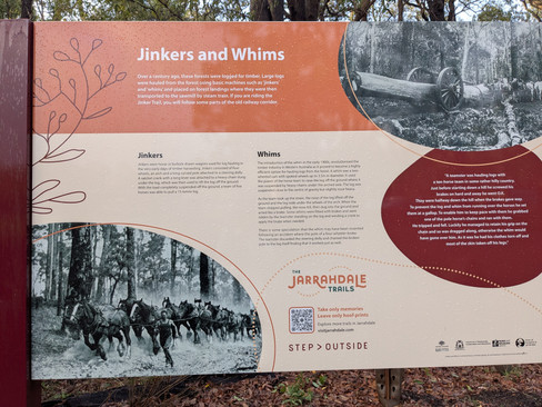
In June 2026 3 brand new trails were opened in Jarrahdale. From the trailhead at Jarrahdale Oval you can explore the 5km Whim Trail, the 12 km Jarrah Trail or the 20 km Jinker Trail - mostly flat trails which wind through jarrah forest.


Whether joining a guided walk or exploring the trails on your own ensure you are prepared for hiking by dressing for the conditions and taking plenty of water. Mobile phones are unreliable in the hills so be sure you tell someone where you are walking. Stay on the trail and please take your rubbish home with you. Some trails are multi-use so be alert for cyclists and horse-riders. Horses are easily startled so slow down and allow them room to pass.


To read more blogs go to:
In the spirit of reconciliation Out and About- Family Nature Connection acknowledges the traditional owners of the Wadjak Boodjar (Perth land) and their connections to land, sea and community. We pay our respect to their elders past and present and emerging and extend that respect to all Aboriginal and Torres Strait Islander peoples today.
As always when hiking in the bush please help to reduce the spread of Phytophthora Dieback by sticking to the tracks and paths, staying out of quarantined areas and, if possible, clean your shoes before and after hiking.


Comments