Yaberoo Budjara Heritage Trail - Neerabup Road to Hester Avenue in Neerabup National Park
- Out and About

- May 10, 2025
- 3 min read

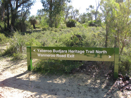
The Yaberoo Budjara Trail is a 28km trail between Neil Hawkins Park in Joondalup and Loch McNess in Yanchep traversing sections of Yellagonga Regional Park, Neerabup National Park and Yanchep National Park. The trail roughly runs parallel to Wanneroo Road and has various access points. Previously we have hiked the 4km section from Burns Beach Road to Neerabup Road so this time we decided to explore the next section. This section can be done as a 4km end to end if you can position cars at either end or as an 8km there and back with access from a small car park off Wanneroo Road at the 10th Light Horse Heritage Trail.
After passing through the gate at the car park turn right to follow the wider side trail to the Yaberoo Budjara. The access trail takes about 15-20 minutes as you wend your way towards the intersection with the Yaberoo Budjara Trail. At this intersection you can turn left (south) to the underpass under Neerabup Road and continue on to Burns Beach Road as we have done previously or turn right (north) to follow the trail to Hester Avenue.


The trail features signage highlighting the trails heritage use as a tribal movement track for the local Whadjuk Noongar people and later use as a stock route after European settlement.

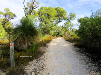


The trail is a popular trail for bikes but we found they generally call ahead to alert you to their presence so it is quite safe. After about 15 minutes you come to a surprising intersection with road work signs as you cross Hall Road.


The trail continues and eventually splits again - this seems to be the turnaround point for the bikers -but we continued to the left where the trail heads downhill to intersect with Hester Avenue at another underpass. There is apparently a trail access gate at the corner of Hester Avenue and Wanneroo Road but we didn't explore the side trail, turning around to retrace our steps. If we walked this again we would also turn around at the Hester Avenue exit sign.


The return took an hour from the underpass back to the carpark. Heading south we had expansive views across the plain as the trail crested a ridge.


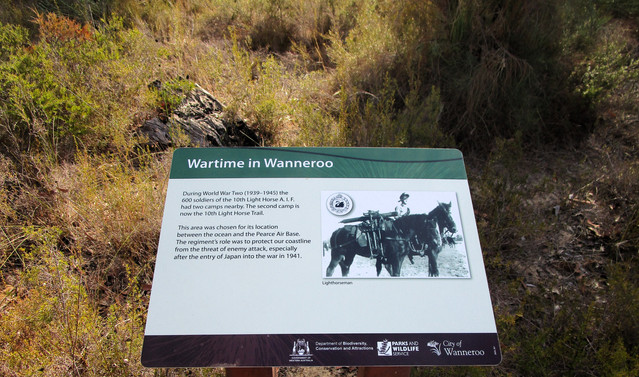
After leaving the Yaberoo Budjara to take the access road back to the car park we made a slight detour to take in a section of the 10th Light Horse Heritage Trail.


A map can be downloaded at https://www.wanneroo.wa.gov.au/downloads/download/158/yaberoo_budjara_heritage_trail_map however the map has not been updated with construction of new roads in the area and does not show Neerabup Road which splits this section into two. It also refers to Hester Avenue as Quinns Road.

To read more blogs go to:
I love wandering along trails, both marked and unmarked, and sharing my discoveries with my Out and About FNC community. If you enjoy reading my blogs please consider a small donation which will be used towards the costs of keeping the website up to date and relevant.

In the spirit of reconciliation Out and About- Family Nature Connection acknowledges the traditional owners of the Wadjak Boodjar (Perth land) and their connections to land, sea and community. We pay our respect to their elders past, present and emerging and extend that respect to all Aboriginal and Torres Strait Islander peoples today.
As always when hiking in the bush please help to reduce the spread of Phytophthora Dieback by sticking to the tracks and paths, staying out of quarantined areas and, if possible, clean your shoes before and after hiking. A spray of 70% methylated spirit and 30% water can be effective.


Comments