Lake Jualbup - Walking Subiaco - Shenton Park
- Out and About

- Dec 17, 2019
- 9 min read
Updated: Aug 25, 2025

The green and shady areas of public open space found in Shenton Park include the tranquil waters of Lake Jualbup, part of the wetlands system of the western suburbs. Lake Jualbup ("a place where water rises in the season of spring") was an important wetland and a source of water and food for the Noongar people who lived in this area and moved with seasonal changes along the Swan River and Swan Coastal Plains. Lake Jualbup is also an Aboriginal burial area and is registered with the State Government as an Aboriginal Site. Noongar people today remain connected to Lake Jualbup and work closely with the City of Subiaco to protect and maintain the wetlands system.


In the early days of white settlement a timber miller named James Dyson worked in the area. Willows and other introduced trees were planted on the island and around the lake sucking up all the water and turning it into a swamp. It became known as Dyson's Swamp and later was renamed Shenton Park Lake, after the land developer and politician, George Shenton. The Aboriginal name "Jualbup" was restored to the lake in 1996.

Over time the lake became a dumping ground but it was eventually cleaned up and a brick wall was built around the lake. Unfortunately the turtles were unable to navigate the wall to nest so it was eventually demolished and native gardens now line part of the lake foreshore providing a wildlife buffer between the public areas and the lake. A few of the willow trees remain but most have been removed and replaced with native species.
A flat paved path follows the edge of the lake. There is a short boardwalk out into the lake. Note the playgrounds are not fenced and are near water.

There are two playground areas located near each other on the south western edge of the lake. The older playground has been redeveloped and is now a mini nature playground designed for younger children. The traditional shade sailed playground is great for climbing and has a dome shaped rope maze, swings, see saws and as a nod to the local turtles three turtle statues to climb over or sit on. Picnic benches are located here and there is a rotunda a little further away. Plenty of open green space invites picnics and ball games.


The path around the lake includes a section of the Beach to Bush Trail, part of the Whadjuk Trail Network, so keep an eye out for the balga trail markers in the pavement. As you head around the lake clockwise from the playgrounds along the walled section there is a toilet block up on the left. Continue on and you will come to the landscaped foreshore areas as you complete the loop. The loop will take you about 20 minutes to complete.


The Walking Subiaco - Shenton Park walk begins at the gazebo on the eastern side of Lake Jualbup near Excelsior Street which is lined with magnificent mature Ficus trees and along which street parking is available. This walk is approximately 4 km in length – allow 90 minutes.

Shenton Park, with its quiet streets and interesting shops, differs in atmosphere from the busy centre of the City of Subiaco. Shenton Park has a wide variety of housing styles and many of the original homes have been carefully maintained, restored and extended. Combinations of colour, design and architectural detail seen among groups of houses contribute to the unique ambience of this area where workers’ cottages built of timber and iron mingle with larger brick houses. The area was known as West Subiaco until the 1930s.The name was used by groups such as the local football club and the boy scouts. Well beyond the western boundary of Subiaco, the name was also adopted by the privately owned West Subiaco Aerodrome.
As you leave the rotunda, cross Excelsior Street and enter Keightley Road then walk a short distance eastwards to Derby Road. The two-storey red brick house on the south-eastern side of the intersection was originally Shenton Park Sub-Station (1923). The sub-station transformed power purchased from the East Perth power station for domestic and industrial use until 1951 when the State Electricity Commission became the supplier.


Turn left into Derby Road and walk northwards to the intersection with Nicholson Road. At the junction of Derby and Nicholson Roads several studio apartments were built on the north-eastern corner in 1995 on the site originally occupied by the Shenton Park Picture Theatre. This theatre is well remembered by many older residents. Films were also shown outdoors in the adjacent Picture Gardens during summer.


The former Shenton Park Hotel (1907), a building of both architectural and historical interest, stands opposite on the south-eastern corner. In 2002 the hotel building was incorporated with a group of new apartments. The Shenton Park Hotel was a popular meeting place for almost a century. It closed in 1999. Locally known as ‘The Shents’, the hotel served the followers of cricket and football in the early twentieth century when these sports were played beside Lake Jualbup.


At the hotel corner turn right and walk eastwards along Nicholson Road. At No.161, between Waverley and William Streets, you will pass the former site of a timber building used by the Army as a Drill Hall (1915). It was also available to the civilian community and is well remembered as the venue for dances and fancy dress parties in the mid twentieth century. The Drill Hall was sold in 1989.
Walk further eastwards along Nicholson Road. The house at No. 134, built in 1917, served for a time as a private maternity hospital – one of several such hospitals in Shenton Park and Subiaco during the early twentieth century. In 1937 it became the residence for the Roman Catholic sisters who taught at the nearby St. Aloysius Convent in Henry Street.


Turn right into Henry Street, one of many quiet streets in Shenton Park lined with a variety of interesting houses and cottages in the architectural style typical of the area and period. Examples of original weatherboard and iron roof cottages can be seen as you walk down this street.


Near the southern end of Henry Street you will see a small park on your left - Joe Tyrie Park. Explore the park to see the doorways linking the park to adjoining properties.

No. 21 Henry Street, opposite Joe Tyrie Park, is now a private home but was originally the Church of St. Aloysius with the convent school behind it (1909). The school was founded by the Sisters of St. John of God, who were followed in 1912 by the Sisters of Mercy. The school enrolled students up to year 10 level. The teaching sisters travelled daily by tram from Victoria Square, Perth, to Shenton Park until 1937 when they moved to Nicholson Road. Forty students attended the school in 1973, the year of its closure. From 1983 to 1991 the buildings were used by the Quintilian Community School.


Continue to Keightley Road and turn right at the corner where the new St Aloysius Church is located then continue walking westwards along Keightley Road.


Turn left into Waverley Street and continue to Onslow Road. At Onslow Road detour left to the Tennis courts where you will find the Rosalie Community Garden tucked in behind the school .The Community Garden features a stunning Noongar Six Seasons Mural.


Returning east along Onslow Road you will pass the front of Rosalie Primary School with St Matthew's Anglican Church on your right.

Almost opposite the Onslow Road entrance to the school you will see a small shop, originally the school’s tuck shop. Rosalie Primary School opened with sixty-seven students in 1906. As you turn left onto Derby Road you will see a wonderful Melski (Mel McVee) mural recently painted on to one of the demountable classrooms.

Follow Derby Road, as it skirts Rosalie Park – a large area of public open space and playing fields used for a wide variety of sports. Until 1998 Rosalie Park was the home ground of the Western Australian Women’s Cricket Association. The park now has a colourful new parkour style playground featuring stunning Olive Cheng murals and situated alongside the mixed use sports courts, table tennis tables. and community plantings.


Continue under more magnificent mature Ficus Trees along Derby Road with Rosalie Park on your left, until you reach Aberdare Road. This section follows part of the Karak Bidi Trail. An example of a Federation style bungalow with the original bull-nosed verandah can be seen on Derby Road. Sir Charles Gairdner Hospital, Perth’s second largest public hospital, can be seen across Aberdare Road, in the City of Nedlands.
Turn right into Aberdare Road, cross the entrance to Violet Grove and turn into Hilda Street. A short distance along Hilda Street turn left into the quiet tree-lined precinct of Cuthbert Street where you will see a number of beautifully preserved workers’ cottages, built of timber and iron.


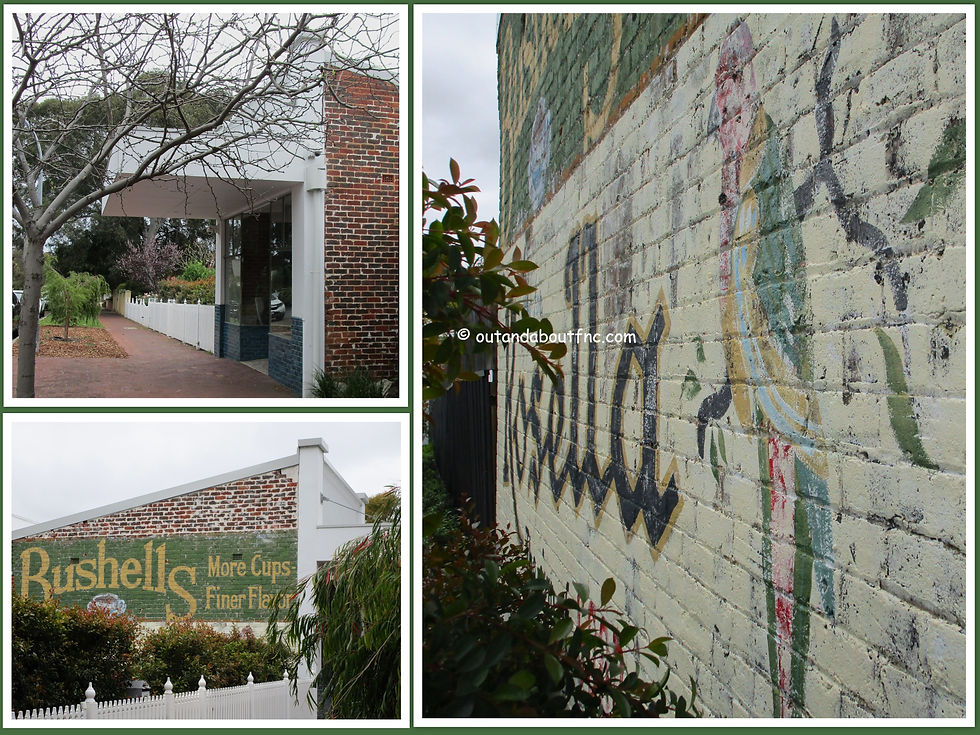
At the western end of Cuthbert Street turn right into Herbert Road and continue to the intersection with Onslow Road. The Shenton Park Community Centre occupies the northeastern corner. In 1983 this extensive purpose-built centre replaced the Progress Hall at 308 Onslow Road, built in 1913. The Progress Hall is well remembered for its ‘Good Companions’ social club. A little further along is an old shop front with the Bushells and Rosella ads still visible on the walls.


Backtrack along Onslow Road in a westerly direction, cross the entrance to Yilgarn Street and turn left into Murchison Street. The former West Subiaco Scout Hall (1929) is a short distance along the street on your left. It was the meeting place of a very active boy scout group. The Army held dances in the hall during the Second World War resulting in the replacement of the floor in 1955. Funds were raised locally and volunteers assisted in the building of a hall for the 18th Group West Subiaco Boy Scouts, later known as the Shenton Park Boy Scouts. The finished building, opened in 1931, consisted of the main hall, a stage and four additional rooms. In 1993 the group went into recess and in 1996 the hall was redeveloped as apartments.


Returning to Onslow Road, continue to No. 345, the Grundmann House (1925) on the corner of Smyth and Onslow Roads. The family home reflects aspects of European Chalet architecture and was designed and built by Albert Emil Paul Grundmann over a number of years. It has been continuously occupied by the family through four generations.

Nearby in Smyth Road you will see several timber cottages thought to be examples of the Whittakers pre-cut Settlers Cottage, a forerunner of the modern ‘kit home’. Six different plans were available in the early twentieth century.


Backtrack to Onslow Road and then backtrack a short distance to Fortune Street where you will turn left. Walk northwards along Fortune Street then turn right into Morgan Street where you will note a variety of housing styles, pretty verge gardens and shady street trees.


Lake Jualbup is visible at the end of Morgan Street. As you near the lake and cross Herbert Road you are following the path of tortoises which leave the lake and cross the road to lay their eggs in neighbouring gardens. The City of Subiaco has placed signs where tortoises are known to cross, asking motorists to take care. On the corner of Herbert Road and Evans Street you will find the Masonic Hall.


Skirting around the southern side of the lake, you will see that the eastern end has been replanted with reeds and other vegetation similar to the natural flora of the area before European settlement.


The Jualbup Painting (1996) by Aboriginal artist Shane Pickett stands near the lake on the eastern side. This public artwork depicts the natural flora and fauna of the wetlands. It was installed beside the lake in 1996 on the occasion of the restoration of the name Jualbup to this area.

You have now returned to the start point of this walk near Excelsior Street. You may also wish to detour to Rankin Reserve for a small shaded and fenced nature playground with adjacent dog park.


We discovered Lake Jualbup as part of the free bi monthly guided see Subi on Sunday walks and returned late in 2023 to walk the Shenton Park Walking Subiaco Trail. This is one of seven self guided walks which form the Walking Subiaco network, designed to explore the unique history, architectural styles, heritage sites and diverse environments found within the City of Subiaco.
Other Walking Subiaco walks are The Triangle, Subi Centro, The City Centre, Jolimont and Daglish, The Commonage and Crawley and UWA. Click for links.
To read more blogs go to:
I love wandering along trails, both marked and unmarked, and sharing my discoveries with my Out and About FNC community. If you enjoy reading my blogs please consider a small donation which will be used towards the costs of keeping the website up to date and relevant.

In the spirit of reconciliation Out and About- Family Nature Connection acknowledges the traditional owners of the Wadjak Boodjar (Perth land) and their connections to land, sea and community. We pay our respect to their elders past and present and emerging and extend that respect to all Aboriginal and Torres Strait Islander peoples today.


Comments